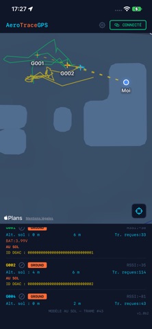

AeroTraceGPS shows the live position of your RC aircraft and gliders on a map, so you can keep track of them in flight and find them fast if they land out of sight. The app connects over Bluetooth to a ground receiver (RX) that picks up long-range LoRa signals from small GPS beacons (TX) fitted to your models. No mobile network is needed in the field. FOR EACH MODEL, IN REAL TIME - Position and flight trace on the map - Height above the take-off point - Distance from you - Signal strength (RSSI) - Beacon battery voltage - Flight state: boot, on ground, low, high, no GPS fix BUILT FOR THE FIELD - Dark, high-contrast interface, readable in sunlight - Automatic reconnection to your receiver - Choose your receiver when several are nearby - Give each model a nickname to tell them apart on site (stored on your phone only) - If a beacon stops transmitting, its last known position stays on the map so you can go and look for it - Configure a beacon's ID directly from the app over Bluetooth - Displays the electronic ID broadcast by each beacon FREE AND UNLOCKED - Free: track one model at a time, and switch between the detected models whenever you like - Multi-model unlock (one-time purchase, no subscription): track up to 10 models, each with its own colour PRIVACY No account, no ads, no tracking. Your location is used only to show you on the map and to compute distances. Nothing is sent to any server. REQUIREMENTS AeroTraceGPS works with compatible AeroTraceGPS hardware: a ground receiver and one or more GPS beacons. See our website for hardware and firmware details. The app has no function without them. The app works while it is open on screen; iOS suspends Bluetooth in the background.